

Good morning Central Coast!
We are off to a great start this week with sunshine and mild temps for all! Get outside and enjoy it though, big changes are headed our way!
Before I get to the storm here is what you can expect this morning. Dense fog is in place for the interior valleys, if you are driving Hwy 166 through the Cuyama Valley take it slow where visibility may fall.
Today is also starting off with cold weather, lows are below freezing for many spots. Grab that extra layer as you head out the door.
Highs today will stay moderate, flirting with 60 for most communities. There is also some gusty winds, just to keep that in mind.

As we push farther into the week rain becomes the story. A large scale atmospheric river is headed our way and will bring significant rain, winds and surf.
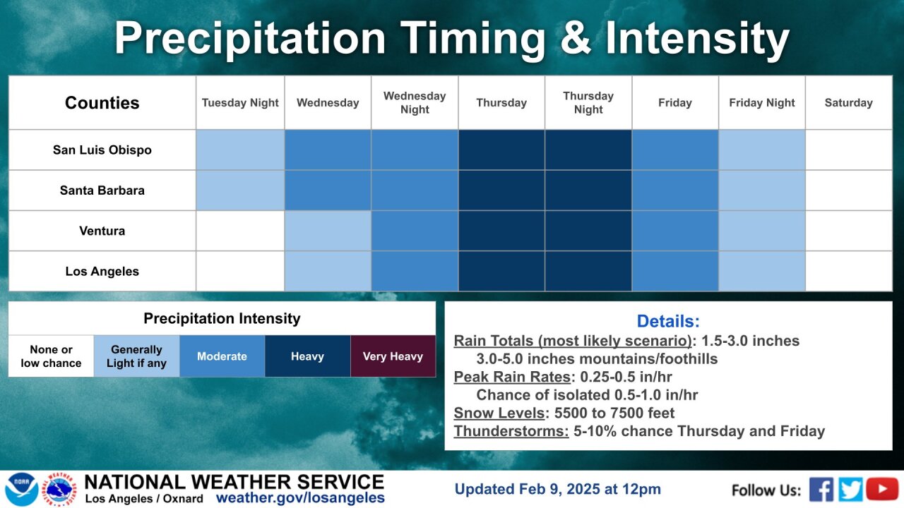
It all begins Wednesday morning with some light scattered showers. These won't amount to much but will be more of an "appetizer" for the core low-pressure that will arrive Thursday morning. The rain Wednesday will clear by mid-afternoon and we will even get a brief break.

The more impactful portion of the storm will be on Thursday. As the cold front slowly traverses south we could pick up INCHES of rain. The heaviest rain is expected Thursday afternoon into Friday morning as the core of this low-level atmospheric river makes its way through.

Get prepared now, I expect flooding in poor drainage spots and urban flood zones.
Winds will also peak upwards of 45 mph, combined with the winds I would not be surprised if power outages occur.
As far as rain totals are concerned we still have some questions the models are not answering but I see agreement on one thing, that we will see significant rain. Here is a look at two forecasts of projected rain. As you can easily tell this is going to be a big one.


Right now my forecast is a bit of a mix of the two. All of our communities will see significant rain but I do think the highest elevations and ridges will pick up substantially more rain than elsewhere. That will cause concern, especially near recent fires.
The KSBY Weather Team will keep a close eye on this system to keep our communities informed and safe through the storm.
Here is that all distilled onto a 7 day forecast.


Have a great day Central Coast!
