


Good morning Central Coast!
After several days well above normal for this time of year plus calm waves and winds we are on the edge of a huge change in the forecast.
First getting the basics out of the way, today's highs will still be above normal for this time of year with most interiors getting into the 70s, most coastal valleys are back in the 60s. Winds have already started to shift onshore, that has provided the moderate cool down.

Today is good 'preparation' weather. Heavy rain is on the way, take the time today to make sure gutters are clear, drainage culverts are clear and make sure you are prepared for rain. We have seen several storms this season with similar accumulation scales. If you flooded already this season take extra precautions.
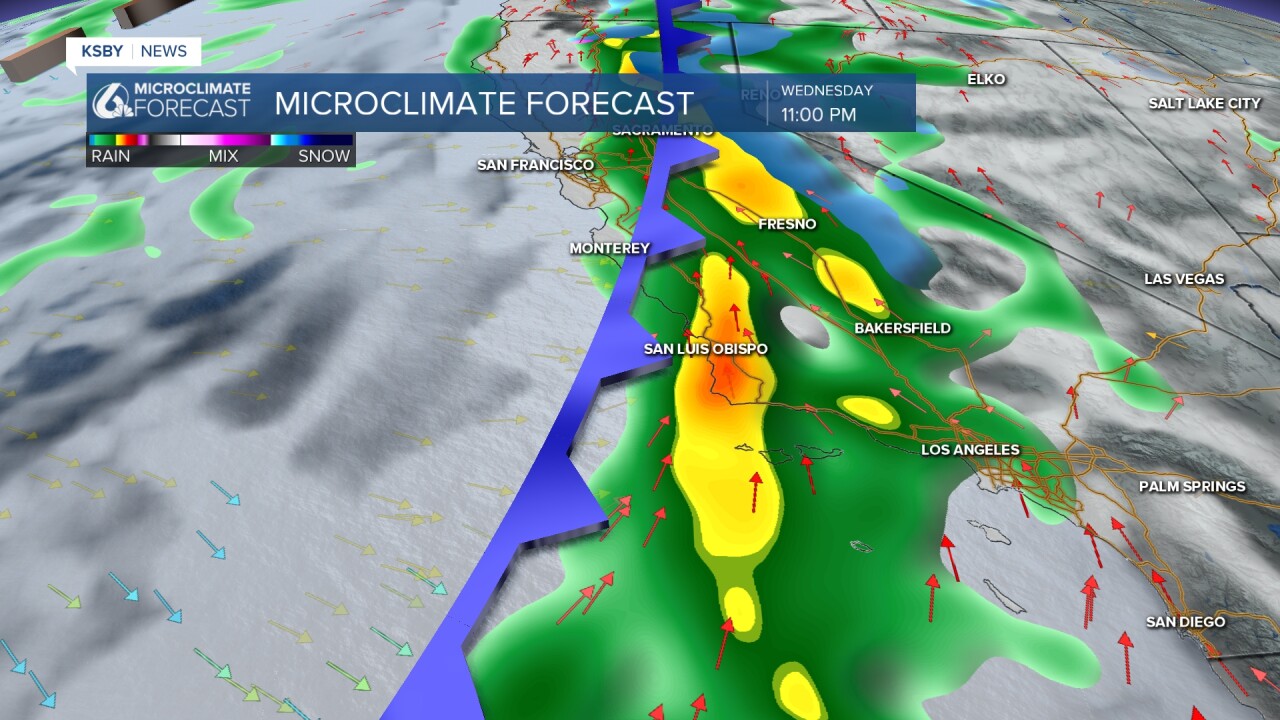
Wednesday afternoon a strong onshore push will drive through the region alongside a strong cold front.

Overnight into early Thursday morning heavy rain is expected alongside strong winds, added waves as well as thunderstorm risk. The greatest period of risk is Wednesday night late into early Thursday morning.
As it clears to the east we will see some scattered storms Friday and Saturday but the main threat (at least for this storm) will be over.

This storm Wednesday into Thursday is an atmospheric river which means it is fueled by a long stretch of subtropical moisture that originates in the central Pacific. Sometimes these are known as the Pineapple Express. ARs are measured on a scale up to 5, thankfully for us this storm is a 1.

An atmospheric river means that the storm system moving into the area will be well supplied with moisture and instability. This will mean rainfall rates between 1/4 to 3/4 of an inch per hour at times especially if thunderstorms develop. Even with a low end AR we can expect these high levels of accumulation.
Our forecast is for between 0.75" of rain in the extreme interiors to 4+" at the mountain peaks. For most communities though, expect between 1.5" and 2.5" of rain.

It isn't just the rain that is of concern, winds and waves are going to be hazardous.
Winds will be quite strong out of the south-southwest Wednesday night into Thursday with some gusts 30 to 40 mph and perhaps even stronger at higher elevations in the Santa Barbara County mountains. The worst of this will be as the cold front pushes through.
As of 11 a.m. Tuesday morning there are no alerts in place. I expect that to change as the storm nears. Alerts for high winds, surf and flooding are likely.
Once this storm clears on Thursday our sights need to focus in on the next storm. Another strong low pressure will reach us by Sunday and last into early next week. Several more inches of rain is expected (this is another AR) alongside more wind and wave concern.
The cooler and rainier pattern will stick around through much of the first half of February.
Have a wonderful day Central Coast, take some time to prepare, things are going to be soggy.
