
Good morning, Central Coast and Merry Christmas to all those who celebrate!
——— Noon Update from Meteorologist Vivian Rennie ———
There are two flash flood warnings in effect for Santa Barbara county through 6 p.m. Thursday night. (They are the bright green polygons)

Turn around instead of driving through flooded roads and stay aware. Flooding is ongoing and there is significant risk for mud/rock/debris slides through this evening.
———10:30 a.m. Update from Meteorologist Vivian Rennie ———
FLOOD ADVISORY ISSUED
Thanks to the continuing heavy rain a flood advisory has been issued for almost all of the Central Coast through 6 p.m. tonight.

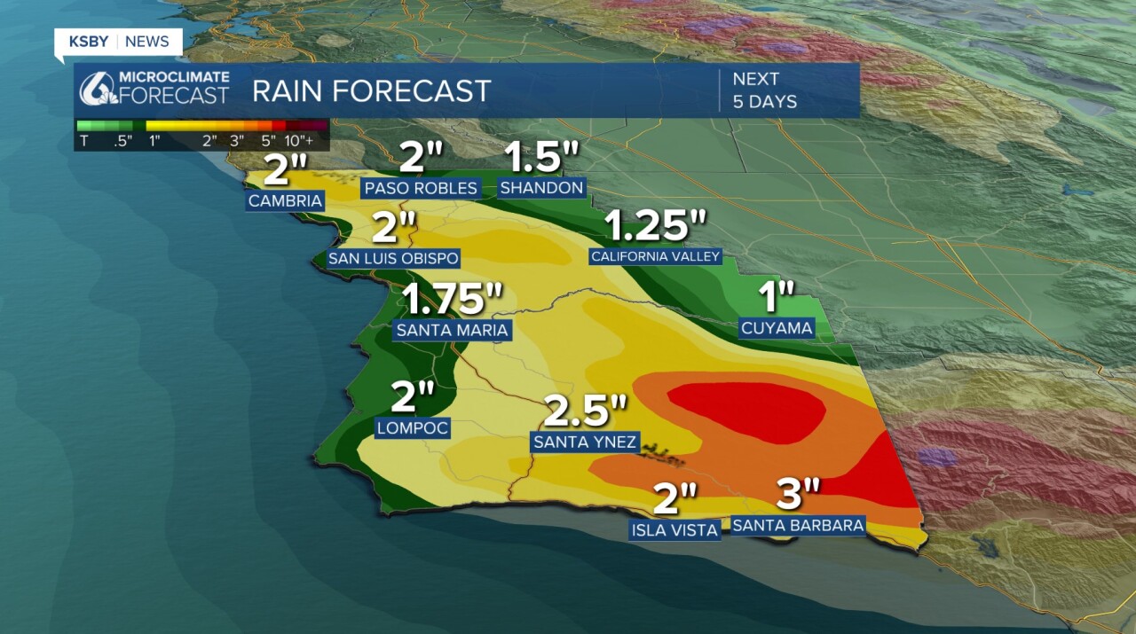
Over the last 3 days most communities have picked up over 2 inches of rain, adding in the rain from the current lines of storms we can expect minor flooding in low-lying and poor drainage areas, rock slides and mud slides, along with minor debris flows.

———5 a.m. Update from Meteorologist Vivian Rennie ———
A strong line of storms is passing through the region this morning and will be impactful.

This line is very fast moving and is bringing with it 50+ mph winds and heavy rainfall. When you combine that with all the rain we saw yesterday, flooding is expected to develop quickly. Through this morning the band will move south, by 7 a.m. it will be towards Santa Maria, Shandon and Lompoc.

By 9 a.m. it will be passing down through Santa Barbara.
Stay off the roads if at all possible as this band moves through, the winds alone are making the roads dangerous.

I will continue to the monitor the storm as it moves south and bring you all the details on the continuing storm as it progresses today!
-Meteorologist Vivian Rennie
PS here is a bit more information on the storm from last nights more in depth article!
———Full Forecast!———
This Tuesday night into Wednesday morning a strong atmospheric river reached the Central Coast and brought inches of rain to the region. Throughout the day, more rain, flooding, and strong winds were the story. As we head into Christmas, there is even more rain and the potential for severe weather on hand. In storms like these, I find it helpful to have a few links on hand.
- Radar
- PG&E Outage Map
- SoCal Edison Outage Map
- Interactive Rain Totals Map
- CHP Incident Information Page
Let's dive into the details! The strong atmospheric river that we have been tracking moved onshore overnight and will continue to bring significant rain for the next few days.
The core low pressure has moved southeast east but following it is a massive area of low pressure and messy storms through the overnight hours.

Early Thursday morning, a thin line of strong storms will arrive and bring some tricky conditions. As that passes south, we have the risk for some severe weather, strong winds, and more heavy rain.

The rest of the day Thursday and Friday will all be messy with scattered storms creating more rain and winds.
As far as what is left in the system, we can expect inches of rain, with the highest totals at the peaks of the Los Padres National Forest. Totals from the storm overall are expected to be around 4 inches for most spots but closer to 10 at the highest peaks on the south coast.
Strong winds are still expected. The high wind warning is in place through Thursday afternoon.

Flood alerts also remain in place for much of the region. Here is a look at the active flash flood and flood warnings.


Additionally, this storm is riling up our seas. There is a surf advisory in place for all of our beaches through 11 a.m. Saturday. Large breaking waves 10-15 ft and dangerous rip current risk are expected.

Here is a little more information about the risk for flooding and rock/mudslides across the south coast.

Additionally, there is enough rotation (vorticity) in our atmosphere with these storms to create the risk for severe weather. The line of storms early Christmas morning has the chance for some weak severe weather, which includes a small chance for weak tornadoes as well as water/land spouts. That risk is small but not out of the question.

Back to the nuts-and-bolts of the forecast. Here is a look at the temperatures we can expect for Thursday across the region.

Here is what all of that looks like on your 7-day forecast!

Have a wonderful evening and a great Christmas to all those who celebrate!
