

Good morning Central Coast!
Thursday was a hot one across the region, even setting new records across much of southern California.

While only one of our communities is listed in that graphic, almost all of our weather stations were within a degree or two of record highs. I hope you were able to get outside and enjoy that weather though, now our pattern will change significantly as storm after storm will push through the region into mid-March.
Starting off today, temps are going to be much cooler. Highs in the mid 60s for most communities. This brings us back down to near normal conditions.

Wave energy is back across our beaches prompting another round of alerts. For our Western Beaches a high surf advisory is in place for breaking waves 8-12 ft and localized sets up to 15 ft with rip current risk. That is in effect through 9 a.m Saturday. For the southcoast waves will be smaller (up to 6 ft) but rip current risk is expected. That has prompted a Beach Hazards Statement in place through 9 p.m. Friday night.

Our first chance for rain, coming from a cold upper low currently located about 200 miles west of Point Conception, is expected to bring a chance of light rain Friday night into early Saturday.
However, the latest models suggest the best rain chances will be focused farther south, with only a slight chance of isolated showers across the Central Coast.
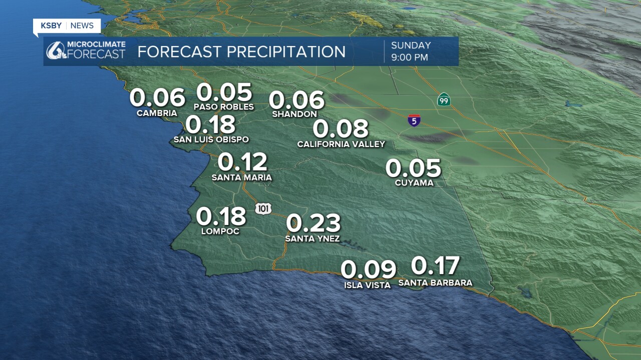
A second system is expected to arrive on Sunday, bringing a higher chance of rain to the area. While amounts are still expected to be light, there is the potential for locally heavier showers, particularly in San Luis Obispo County. This system will also bring strong west to northwest winds, with gusts of 30 to 45 mph possible near the coast.
Snow levels will be falling with the passage of this system, potentially reaching the Grapevine on Interstate 5 overnight Sunday into Monday. While accumulations are expected to be minimal, some brief travel delays are possible.
A brief drier period is possible later Monday and Tuesday, but a cold air mass will remain in place, and another storm system is expected to arrive by Tuesday night and Wednesday. This system has the potential to be the most significant of the three, with more moisture content to fuel the system. Confidence is high that this system will bring rain to the region, though the exact timing and amounts are still uncertain.
There are potentially more systems to look at later next week. Models are still suggesting activity. It is a time frame worth staying tuned it.
Here is a look at the extended forecast. One thing that is easy to see... lots of rain chances through the 7 day forecast and into mid-March.


Even into the 8-14 day forecast, cooler and rainier weather is expected.


Have a great day Central Coast!
