

———10 a.m. update from Meteorologist Vivian Rennie———
The tropical disturbance Dave Hovde-KSBY and I have been monitoring has been upgraded to a Tropical Storm and is expected to rapidly intensify as it begins its track north. Tropical Storm Hilary will move north and eventually brings us a chance for some significant rain early next week. The best chance is Sunday night through Tuesday.
This system is still a while out and tracks are likely to shift but I do expect that the Central Coast will be impacted, particularly on Monday.
——— Original Article———
Good morning, Central Coast!
As we kick off the morning there is a lot going on, I want to first urge everyone to stay weather aware over the forecast as there are many moving parts and potentially large impacts looming.
Now is a great time to make sure you have theKSBY Microclimate Weather Appon your device.
Overnight the lingering monsoon pattern has kicked off storms in the LA Basin that are headed north. Thankfully these storms are not going to directly impact the Central Coast but they do show how much energy this air mass has and what we can expect for the afternoon.

By afternoon some storms are expected to pop up in the interior valleys, they will be short lived but still something to focus on. This activity is driven by monsoonal moisture combined with daytime heating. Any isolated thunderstorm should stay in the deep interior and dissipate as temperatures cool later this afternoon and into early this evening.

The interiors are going to be humid and hot, the perfect conditions for those storms to develop.
At the coast, it's a much different story with beaches on the cool side due to marine clouds but a steep temperature gradient as you go inland. Temps on the coasts will be in the 60s, stretching to the 80s for the coastal valleys.
Temperatures look to cool slightly on Thursday but more significantly on Friday and Saturday as a trough of low pressure off the West Coast will deepen the marine influence. Temperatures begin to warm again Sunday through Tuesday.


Now turning to the 'talker' of the forecast, tropical activity headed our way!
South of Mexico a currently unnamed (once it intensifies to a tropical storm it will become Tropical Storm Hilary) is strengthening and looks to bring intense tropical activity to Baja California later this week and will likely bring us some significant rain by early next week.
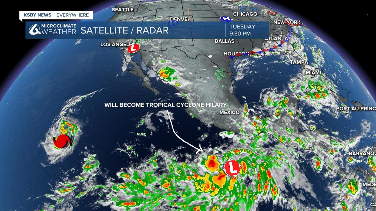
Tropical Storm Hilary will likely introduce some moisture to Southern California and the Central Coast. We would not be in the direct path of the system but related moisture could stream to the north of it. This is something to watch as we get into the weekend and early next week.

Models indicate that the system is either potentially a tropical storm or just a little weaker on arrival to SoCal/Central Coast area (after being a much stronger storm before it gets here). Important to note that a storm *does not* need to be a hurricane to do a lot of potential damage. The amount of water and wind with thunderstorm and surge potential create a hybrid of weather conditions that California doesn't see often.
Rainfall will hug the potential track so models are putting a lot in SoCal for now but you can't breath easy on the Central Coast yet there is too much uncertainty. Even a glancing blow could deliver inch plus rain, and a more direct or lingering track could deliver more.
Have a great day Central Coast!
