
A storm we’ve been anticipating for more than a week is drawing closer and still looks to deliver some heavier rains starting Tuesday and lingering into Wednesday.
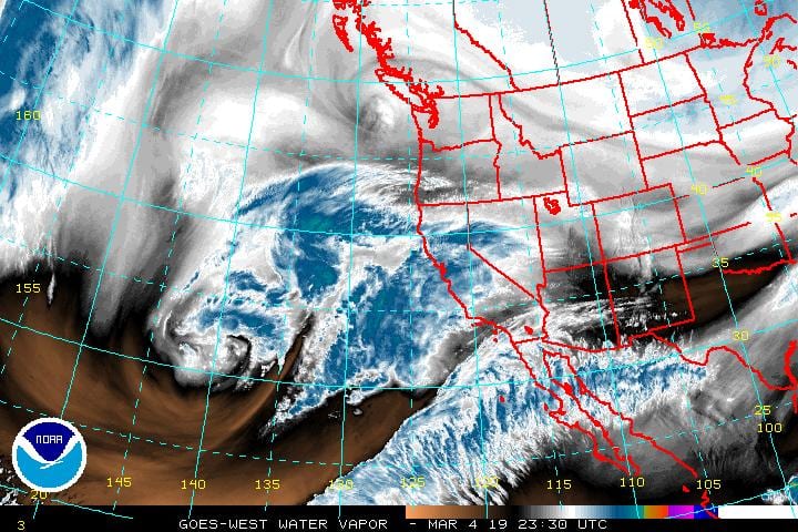
Here is the look at the alignment of the "Atmospheric River" of moisture supply for the Tuesday storm. Looks to be right on us.
Posted by Dave Hovde-KSBY on Monday, March 4, 2019
The system is powered by an “atmospheric river” which is a plume of sub-tropical moisture which enhances a storm’s ability to produce not only more rain but higher rain rates.
This is the Storm Prediction Center's outlook for thunderstorm potential for Tuesday into Wednesday's storm. A flash flood watch has already been issued for all burn areas in SB and Ventura counties.
Posted by Dave Hovde-KSBY on Monday, March 4, 2019
Thunderstorms are also possible with this system into Wednesday which also contributes to higher rain rates. .5-1″/hr. rain rates are possible along with 1-3″ of rain at the coast and up to 5″ cumulative rain in some south facing foothills and mountains. This raises the concern about flooding. A flash flood watch has been issued for all recent burn areas in Santa Barbara and Ventura counties.
A flash flood watch has been issued for all burn areas in Santa Barbara county for Tuesday's rain event. High rain…
Posted by Dave Hovde-KSBY on Monday, March 4, 2019
Southeast winds 15 to 25 mph with gusts to 40 mph are also possible with the storm Tuesday night into Wednesday. No advisory is in place for that yet but certainly is possible.
Snow levels start very high at 7500ft but will ultimately lower to 4000ft by Thursday.
Friday and Saturday look partly cloudy but windy out of the NW 15-30mph. Models are suggesting another storm may be possible as we begin next week.
