A series of storms is in the forecast starting as early as Wednesday night into early next week.
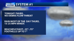
The first storm brings rain a little after 10 p.m. Wednesday and through the course of Thursday.
This system is expected to bring anywhere from 0.25-1 inch of rain with a slight chance of thunderstorms Thursday afternoon.
Expect south to southeast winds sustained at 15-25 mph.

Daytime highs will be in the low-60’s for Thursday with overnight lows around 50.
A second storm is not far behind, arriving Friday night and lasting through Saturday.
Rainfall totals will be higher than the first storm, averaging 1-3 inches with potential for rain rates of .5 to 1 inch of rain per hour.
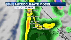

This could cause debris flows with significant flows and possible flash floods for recent burn scar areas.
A Gale Watch is in effect Friday afternoon through Saturday morning as winds pick up to 30-45 mp with gale force winds up to 60 mph is some isolated areas.
Strong winds could drive waves 8 to 11 feet with max sets lasting 14 seconds.
Fallen trees and increased travel delays are also possible.
A smaller and weaker third system could bring lingering showers with about .5″ of rain Sunday into Monday, but conditions should start to clear up by Tuesday afternoon.
