
One of the busiest travel days of the year will be greeted with some potentially challenging conditions. Rain is likely Wednesday. Timing for the Central Coast puts the bulk of the moderate rainfall over the area in the afternoon into the late evening and early overnight hours with the main band moving from the NW to the SE.
Strong south winds will also develop ahead of the frontal boundary and locally winds of 15-30mph should peak in the afternoon into the early evening.


Some light showers could begin as early as late tonight into early Wednesday morning but again the main activity looks to be in the afternoon in the form of rain, there is some minor thunderstorm potential later Wednesday night as cooler and more unstable air moves in after the main frontal band of rainfall.
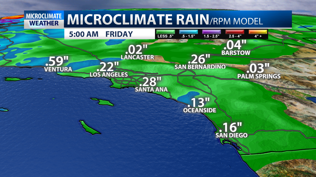
In terms of rain potential: a wide range is in play. Inland area could see .25″ or even less while coastal areas could see as much as 1.5″. I think a lot of totals will be closer to .50″ but the full range needs to be considered. I think there will be less rain south of SB and Ventura Counties and more likely north. Thanksgiving Day looks generally quiet outside of early shower possible but in northern CA another system Friday will continue to bring rain to recent burn areaas (where there are flood watches in place) and significant snow to The Sierra where above 7,000 feet more than a foot is possible.


The good news is that rain is needed and smake haze will be reduced but recent burn scars will have some threat of debris flow. The Thomas Fire burn scar is not expected to be a problem locally as rain rates look to stay under .40″/hr.
Temps drop into the 60s for highs essentially everywhere with the rain and the front and post frontal cold air lingering Thursday and Friday. SLO county could see a shower possibility Friday from that storm expected to primarily hit Northern California but totals would be very light if it happened.
The rain will probably still be significant enough to cause some issues in and around the recent burn areas, especially the Woolsey and Hill burn areas, with mudslides and rock slides possible. At this point, it appears that there is just a 10% chance that rainfall intensities will meet USGS debris flow thresholds across the Woolsey and Hill burn areas. Those thresholds are 0.50 inches in one hour, 0.30 inches in 30 minutes, and 0.20 inches in 15 minutes.
The extended forecast looks active. Wednesday of next week thru the following weekend could feature more rain with a significant potential system to start December. The upper air pattern is open to steer storms into The West. This all looks to be the “real” start of the winter rains. We’ve been quiet since our one-off system Oct. 3rd.
